
The Land Of Canaan
Ancient Palestine
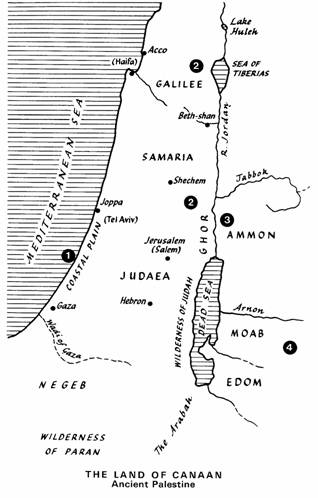
Smallness of the land of Canaan.
It is quite a small country amounting to a little less than 10,000 square miles (if the territory east of the Jordan is included), smaller therefore than the State of Maryland in the U.S.A., and only a little larger than Wales in the U.K..
The four natural regions of the land of Canaan.
There are four principal natural regions, dividing the country into parallel strips:
1. The coastal plain of the Mediterranean from the Wadi of Gaza (the modern Ghazzeh) to the last spur of the Camel range.
2. Between the Mediterranean and the Jordan: the hills of Galilee (to the north) which, after the gap made by the plain of Jezreel, (or Esdraelon) continue to the south by the mountain masses of Samaria, (or Mount Ephraim) and of Yahudah.- (Judaea)
3. The Ghor or valley of the Jordan.
4. To the east of the Jordan, between and the Arabian Desert the mountain mass of Bajan, Gilead, Moab (in general the mountains and steppes of the modern kingdom of Jordan).
1. The coastal plain
From Mount Carmel to the Wadi of Gaza is the low coastal region, rectilinear in shape (save for the Carmel spur). Along the whole line of coast is a fringe of sand dunes. To the east of these dunes a plain of rich soil brought down by the streams forms the richest region of Palestine. The climate is mild, the soil fertile, and there is enough water. As the east is approached the plain becomes increasingly drier. This is the corn-growing region and is also suitable for cattle rearing. The richness of the soil here forms a strange contrast with the poverty of adjoining Yahudah.
2. In the north is Galilee, the land of hills, springs and forests. This pleasant region is formed by the two mountain masses with the fertile plain of Jezreel (or Esdraelon) in between. To the south of the plain of Jezreel is the massif of Samaria (with Shechem). Undulating country with abundant springs and rich pastureland. To the south of the massif of Samaria is that of Yahudah. The plateau stretches from the Hebron to Jerusalem; there are highlands with a harsh winter climate and few springs or streams, but wells have been dug almost everywhere. little or no forest land occurs and cultivation is difficult. There are steppes on which flocks of sheep or goats can find food. In the west between Yahudah and the Mediterranean the Shephala lies the corn-growing district with abundant water. To the east of the Jordan, the wilderness of Yahudah (or Judah) slopes down to the Dead Sea. To the south of Yahudah is the Negeb. a dry. desert region.
3. The Ghor ('hole' or 'hollow').
This is the long rift valley stretching from the lake of Tiberias to the Dead Sea. Its lowest point occurs where it enters the Dead Sea, 1,290 feet below the level of the Mediterranean. The Ghor is a desert through which the Jordan flows; but in the narrow alluvial plain there is plentiful vegetation.
4. The plateaux of the East (Transjordania).
To the east of the Ghor, dominating the rift from a height of 4000 feet a high plateau rises abruptly which then slopes down to the eastern desert We can here distinguish the three principal regions mentioned by the Scriptures: To the north the land of Gilead, not unlike Yahudah. In the centre, Moab, which is fairly fertile. In the south Edom, almost a desert.
Yitschaq YAHWEH's Chosen One Yitschaq Sitemap Scripture History Through the Ages Yitschaq The Hebrew Clan The Land Of Canaan Legal Question Ishmael Abraham's Heir Spiritual Question Ishmael And Mohammed Who Was Yitschaq Yitschaq's Mission Yitschaq's Life Yitschaq's Life Journeys With His Flocks Yitschaq The Story-Teller